DOCOMO handles the flight support s...
14
01
DOCOMO handles the flight support software "Skydio 3D Scan" by Skydio, US drone maker
NTT DOCOMO has started handling Skydio and Inc's flight support software "Skydio 3D Scan".DOCOMO has been providing technical verification and development of Skydio 3D Scan since 2020, and will be available as Launch Partner this time.
"Skydio 3D SCAN" is a flight support software that can automatically shoot structures according to the purpose of use, such as 3D and 2D shooting.Using the same software, the drone recognizes the structure and the data acquired by the upper and lower cameras, even in an environment where GPS is difficult to obtain, and flies automatically while avoiding obstacles.。
In addition, a simple setting allows flights according to the purpose.First, specify the area of the structure, such as the top, lower surface, width of the structure, and set the distance to the structure and the ratio of the overlapping range of photos to be taken.When creating a 3D virtual model on a digital space, approach the structure and get many photos, and in situations where speed is required, such as grasping the situation at the site, a small number of photos are obtained.
By using Skydio 3D Scan, the drone itself is automatically adjusted by the drone angle and the direction of the aircraft.In addition, pilots can concentrate on safety management because they can set safety functions so that drones do not appear outside the determined area.In addition to Skydio 3D Scan, if you have AI analysis functions, 3D construction software, and viewers of "docomo Sky", you will be able to take detailed photos along with the flight trajectory.
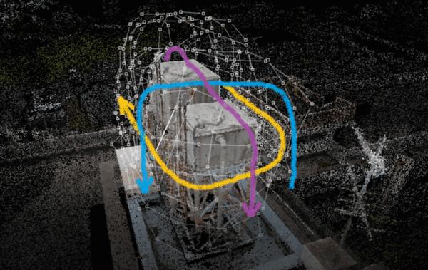
The features of the flight support software "Skydio 3D Scan" are as follows.
Realizes structures suitable for 3D modeling, 2D Orso, etc.
It is possible to shoot an environment and complex structures that are difficult to obtain GPS, which was difficult to fly with conventional software.
Regular and efficient shooting is possible
By utilizing Skydio 3D Scan, you can shoot structures more regularly and efficiently.In addition, since the number of photos has been taken, it is possible to improve the efficiency of confirmation work by inspection.
Simple operation
Until now, high pilot skills were required to shoot structures in 3D, but by using Skydio 3D Scan, even in an environment where GPS is difficult to obtain, it will be automatically flighted with simple operation.It is possible.
Utilization in AI analysis
Since the shooting is performed while maintaining a constant interval from the structure, an image that is easy to analyze can be obtained.


![[Kill personally developed games] Top class in app history! Too beautiful water puzzle "a [Q] ua" | Famitsu App for smartphone game information [Kill personally developed games] Top class in app history! Too beautiful water puzzle "a [Q] ua" | Famitsu App for smartphone game information](https://website-google-hk.oss-cn-hongkong.aliyuncs.com/drawing/article_results_7/2022/3/3/66755df992ff2d2b1e1ab43844ef9f88_0.jpeg)


![[Latest in 2021] 10 recommended seat covers for cars!If you want to improve the texture and functionality of the car, choose the mounting type and material. [Latest in 2021] 10 recommended seat covers for cars!If you want to improve the texture and functionality of the car, choose the mounting type and material.](https://website-google-hk.oss-cn-hongkong.aliyuncs.com/drawing/article_results_7/2022/3/3/e5b44589e77141f3a633189165fb6f60_0.jpeg)